After hiking this trail many times, I’m sharing everything you need to know about hiking to McAfee Knob including how to find parking, the best trail to take, how to catch a sunrise, and camping options.
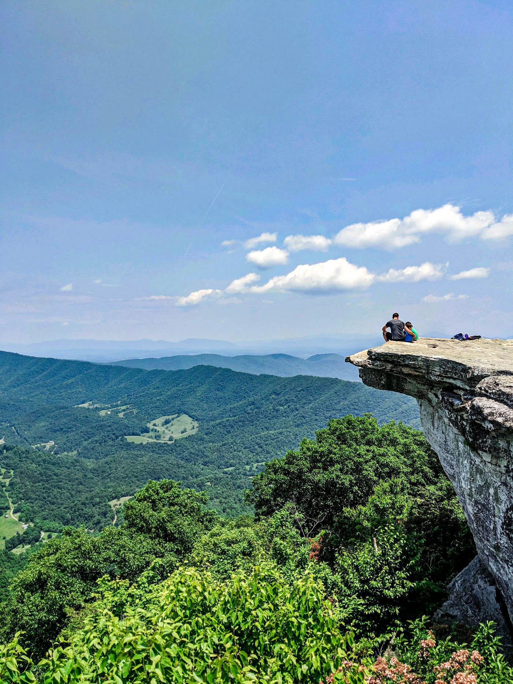
McAfee Knob is the most photographed spot on the Appalachian Trail for good reason – it is absolutely beautiful. When you reach the end of the trail, you’ll be treated to an amazing 270 degree view overlooking the surrounding mountains. And I can confirm the view is even more stunning in person than it is in photos.
I’ve hiked to McAfee Knob many times in all four seasons and while the view in fall is particularly spectacular, this hike is gorgeous any time of year.
In addition to being a part of the iconic Appalachian Trail, McAfee Knob is one leg of the popular backpacking route, the Virginia Triple Crown, along with Dragon’s Tooth and Tinker Cliffs.
Even though McAfee Knob has a reputation for being very strenuous, casual hikers absolutely can and should make the trip up. A few years ago my oldest son hiked the entire trail for the first time at just five years old. We took lots of breaks and had plenty of snacks along the way but we were able to reach the top and had a great time doing it.
McAfee Knob Hike
Length: 7.8 miles or up to 11 miles from the Greenway Parking Lot (Out and Back)
Elevation Gain: 1700 feet
Difficulty: Strenuous
Great for: Families, Photography, Trail Running, Pets
Location: Northern Roanoke County on Catawba Valley Dr.
When to Visit: Any time – the view is always beautiful
How we rate it: 5/5, It’s an easy to follow, at times steep, trail with an amazing payoff. There’s a reason so many people visit.
Parking options *Update 2023-2024*
Beginning November 30, 2023 the main parking lot is closed for construction of a footbridge across Catawba Valley Dr.
Based on current information the construction could take up to a year to complete.
The parking is a bummer, but it’s really good they are adding the foot bridge. It’s going to increase safety for the thousands of people that cross Catawba Valley Dr for years to come.
Fear not, you can still hike McAfee Knob.
Below are the parking options and a couple tips and a map of where to park, additionally, I’ve covered a bit of information on each one.
- There is limited roadside parking on Old Catawba Rd.
- There is Greenway parking at the Catawba Sustainability Center.
- There is very limited parking at the Catawaba Farmer’s Market.
- You really need to consider carpooling during the closure.
- If you park in a No Parking zone or block the road you will get towed.
Trailhead Parking
The Main parking area is closed until the pedestrian bridge is completed. So, this is not an option right now.
Do not park on the road. Your vehicle will be towed. Not maybe – definitely. Police are very strict about this because road parking is dangerous on Catawba Valley Dr.
Old Catawba Rd Parking
Old Catawba Rd is very close to the trail head. The road is a steep series of switchbacks and there are a few sections where you can park along the road. The most obvious spot is just before the stop sign, but if those few spots are taken you can head a little further down the road to more roadside parking.
If you park on Old Catawba Rd make sure your vehicle isn’t blocking the road – you’ll get towed.
Old Catawba Rd is your closest parking option. The Greenway Parking adds some significant mileage to your hike.
Greenway Parking
You can find the additional parking areas at 4965 Catawba Creek Rd and 5061 Catawba Creek Rd.

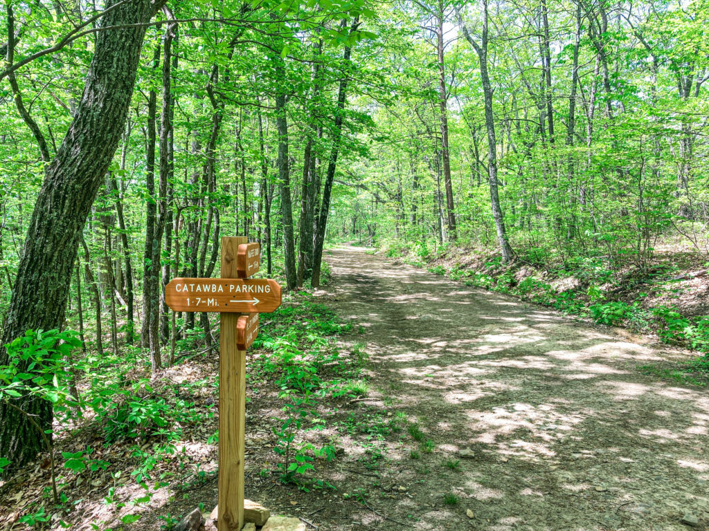
There is a greenway that provides access to the fire road and Appalachian Trail from these parking lots. The greenway from the Catawba Sustainability Center to the fire road is 1.7 miles ONE WAY.
You’ll pass through a metal gate secured with a chain to reach the greenway. It is obvious where to go, so you shouldn’t have any problem finding it.
The greenway begins as a paved road, but as you get closer to Catawba Valley Dr a narrow trail shoots off to the left. From there on you will be following orange blazes until you reach the fire road.

There is clear signage along the trail. Be prepared for a bit of a climb. It seems to me this is one of the steepest climbs along the hike to McAfee Knob.
Once you reach the fire road, you can continue up towards McAfee Knob by going left or turn right and head over to the Appalachian Trail. The walk to the Appalachian Trail is a close to 0.1 miles.
I prefer the trail going up and down but plenty of people I’ve spoken to prefer the fire road both ways.
Parking at the Farmer’s Market requires a short road walk to reach the sustainability center where you can access the greenway. The extra distance is around a quarter mile each way.

Parking at the Catawba Sustainability Center is your best option for the greenway.
For a more exhaustive description of the Catawba Greenway System, check out this Roanoke Appalachian Club post.
McAfee Knob Shuttle
This is your best option to avoid adding a lot of mileage to your hike besides parking on Old Catawba Rd.
The shuttle runs March through November on Friday, Saturdays, and Sundays. Tickets are ONE WAY and cost $5 per individual plus a $1 fee per transaction.
You can prebook your trip and view the schedule and pricing on Roanoke County’s website.
Walkup tickets can be purchased at the Park and Ride or at the McAfee Knob trailhead but must be paid with credit or debit cards.
The shuttle leaves the Park and Ride for its first trip at 7:00 am and returns every 30 minutes. It reaches the McAfee Knob trailhead at 7:15 am and returns every 30 minutes.
Riders with pre purchased tickets take priority over walk ups.
If you purchased tickets to and from the trailhead and miss your return trip you will be allowed to ride a later shuttle, but if you miss the final shuttle of the day you are responsible for getting back to your vehicle.
The last shuttle run varies throughout the year:
- March last run at 6:15 pm
- April – September last run at 6:45 pm
- October last run at 6:15 pm
- November last run at 4:45 pm
Finally, ADA service dogs are allowed on the shuttle but pets in general are not.
If you purchase your tickets online you can choose a pickup and drop off location from the following spots:
- Orange Market
- Park and Ride
- Longwood Park
- South Broad Street Parking Lot
hiking symbols are parking locations where you can walk to the trailhead. Parking symbols are locations that should be used for carpooling or the shuttle services.
There is a lot to consider there and each group will have to weigh the costs and benefits of each option.
Read More – The 15 Best Hikes Near Roanoke, Va
Hitting the Trail
The combination of distance and elevation make this a pretty strenuous hike. Make sure to bring a little extra water or a water filter, there is a spring near the second shelter.
If you were able to park at the main lot, you will cross Catawba Valley Dr. and enter the trailhead there.
You will immediately begin with a steep ascent that leads to stairs.
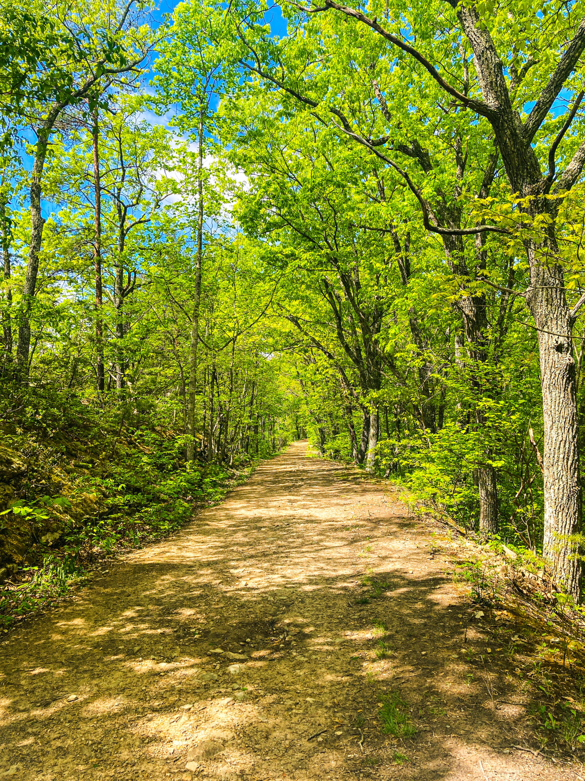
Once you reach the top of the stairs, you will be under the forest canopy for the rest of the trip unless you decide to take the fire road.

Appalachian Trail or Fire Road
You intersect with the fire road after about half a mile and it is a more direct option but I prefer to use the trail.
The trail to McAfee Knob is part of the Appalachian Trail, a 2000+ mile trail that runs from Georgia to Maine.
This is the better option if you are trying to connect with nature or camp. There are also more places to rest, especially at the shelters. And there are picnic tables and restrooms available at both shelters.
But there are times when the fire road would be preferable. If you have small children or are going for a sunrise or sunset hike, the fire road is probably a better option.
The fire road is wide and meant to have vehicles travel on it so there are fewer sections where tripping is a concern. Lighting is also better because more light penetrates the forest canopy on the fire road.
On the Appalachian Trail
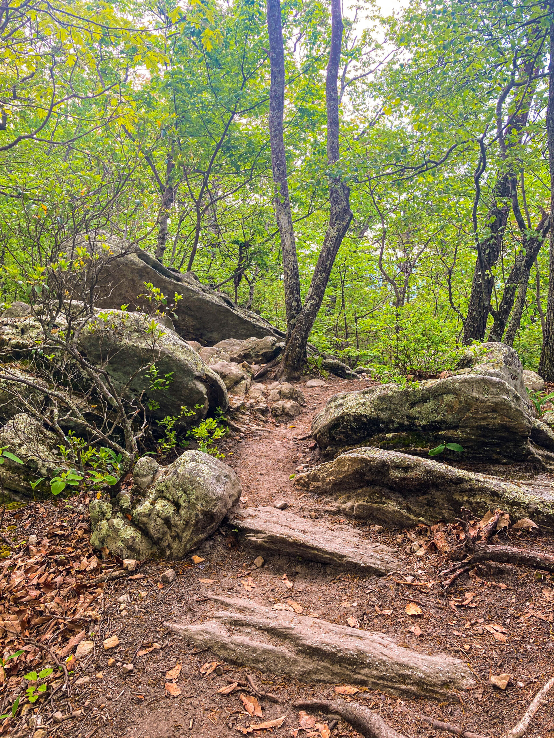
The trail weaves through the forest upward at a steady pace with only the briefest level ground or descending terrain, so take breaks as you need them.
Along the path you will pass two shelters: John Spring Shelter and Campbell shelter. Each shelter has a vault toilet nearby and a bear box, if you decide to camp. (More info on camping below).
The trail will be steep for a few miles until you intersect again with the fire road. If you are hiking on the Appalachian Trail, you will cross the fire road and continue up the trail. If you are hiking on the fire road, you will turn left at the sign to continue to McAfee Knob.

After the fire road, the trail doesn’t let up. You will be ready for a long break once you finish the climb to the top.
Along the way there are several massive boulders. You are pretty close once you reach this point. On some longer hikes, or at least steep hikes, I like to have a landmark or waypoint that I can motivate myself to push through. The boulders are that spot for me. It’s still steep but you are close now.

As you get closer to the overlook, the view will begin to open up but nothing as dramatic as the view from the top.
There is an opening where the trees fade and mountain laurel replace them. Turn left, you did it!
Once you reach McAfee Knob, plan on spending some time. There is plenty of room to spread out and eat your lunch or a snack.

Of course, you’ll want to take some photos before you head back down.
There is a reason this is the most photographed spot on the Appalachian Trail.
It’s absolutely beautiful with wide open views. And the rocks jut out at the perfect angle for someone to take your photo overlooking the rolling mountains.

It’s unlikely you will be alone at the top, so if you solo hike it should be easy to find someone to snap an appropriately heroic photo of you looking off into the distance.

There are a few different ledges where you can take a great photo overlooking the valley. Most people tend to congregate on the largest ledge. But if that spot is crowded, there are a few other small rock ledges nearby that are also great for photos.
The photo above was taken at one of these alternate spots. It’s still an amazing view and you won’t have to worry about being rushed by other people waiting for their turn.
The trip down is much easier than the hike up and if you have young children with you it may be a good idea to take the more direct route down on the fire road.
I still prefer the main trail for hiking back but my kids weren’t so keen last time.
Read More – Dragon’s Tooth Hike: Everything You Need to Know
Sunrise and Sunset at McAfee Knob
With its 270 degree view, McAfee Knob is a beautiful spot for both sunrise and sunset.
Be sure to check what time sunrise or sunset are before heading out on your hike.
It will take between an hour and a half to two hours to reach the overlook on average unless you are a fast hiker. You will want to be at the overlook about 30 minutes before sunrise and closer to 45 minutes before sunset for the prettiest views.
As you are hiking in the dark before sunrise or after sunset, be sure to bring a headlamp or flashlight. This would also be a good time to take the fire road for a smoother path.
Keep in mind that sunrise in particular is very popular at McAfee Knob so there will likely be other people around. But it is still a beautiful experience.
Camping Near McAfee Knob
If you decide you want to camp near McAfee Knob, there are a few options.
There are two shelters along the Appalachian Trail leading McAfee Knob: John Spring Shelter and Campbell shelter. Each shelter has a vault toilet nearby and a bear box for storing food.
McAfee Knob is part of the popular backpacking route, the Virginia Triple Crown and popular amongst Appalachian Trail section hikers, so there are likely to be other hikers using the shelters as well. It’s a good idea to bring your own tent in case the shelters are full.

There is ample room to set up a tent near the shelters so you shouldn’t need to camp away from the designated areas. If you want more specific information about how to limit camping impact on the environment you can review the recommendations of the Appalachian Trail Conservancy.

McAfee Knob truly is one of the best hikes in the area.
I love Dragon’s Tooth and Devil’s Marbleyard. They are unique, challenging hikes and the trails are more fun and exciting, in my opinion.
However, McAfee Knob will make you feel awe. Once you walk out onto that jutting rock, the world opens up and the mountains stretch to the horizon. It’s the kind of beauty you feel as much as see. Every step of the trail is worth the view.

Read More – 30+ Great Things to Do in Roanoke, VA: Tips from a Local
After the Hike
There’s a good chance you’ll be ready to grab a bite to eat when you finish your hike. If you have a bit of time and don’t mind the drive to south Salem, Abrakababra is, in my opinion, the most under appreciated place to eat in the Roanoke area. They specialize in gyros and if you can appreciate an uncomplicated thing done exceptionally well this is a must stop.
If you are looking for a great breakfast option or a snazzy brunch Our Daily Bread is amazing.
And if you want to check out more local trails, head to our list of the 15 Best Hikes near Roanoke.


Leave a Reply